
Extreme Rainfall Triggers Devastating Floods in the Chittagong Hill Tracts; Highlighting Urgent Needs and Sustainable Actions
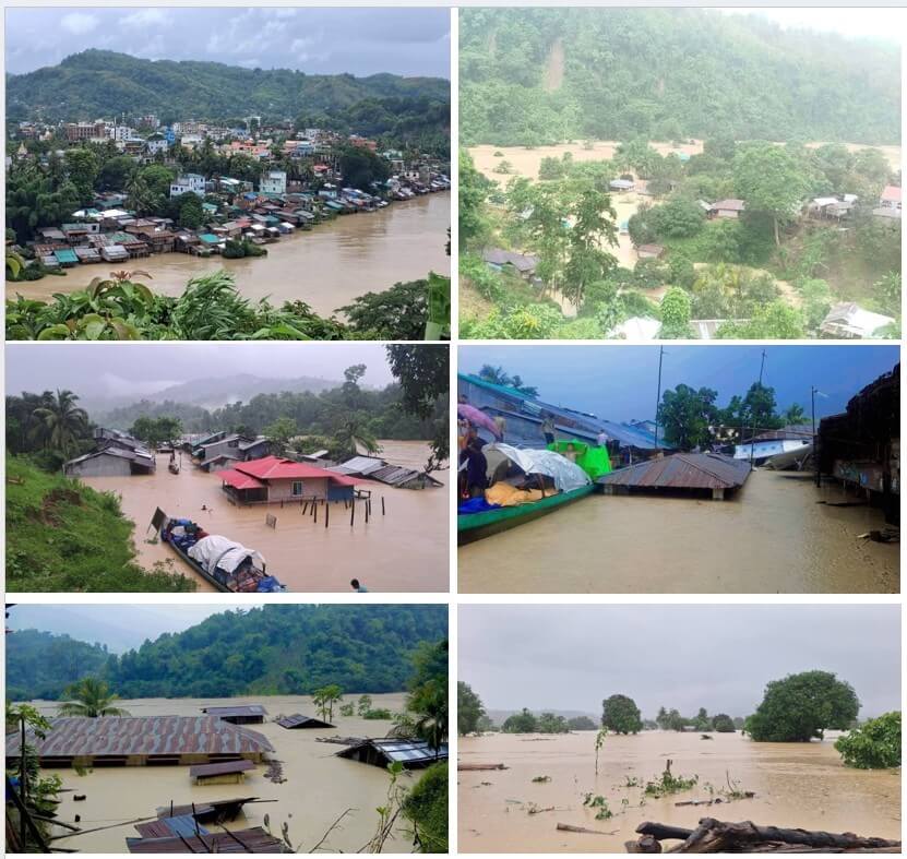
Photo: collected
The Chittagong Hill Tracts (Bandarban, Rangamati, and Khagrachhari) are facing severe flooding following several days of exceptionally heavy monsoon rainfall. Intense downpours caused rivers and streams to overflow, triggering flash floods and landslides across the hilly terrain. Overflowing rivers, hill streams, and saturated slopes have inundated settlements, damaged critical infrastructure, and isolated numerous remote communities. The disaster forms part of a wider flood emergency across southeastern Bangladesh, affecting hundreds of thousands of people and causing significant loss of life and livelihoods.
This year’s floods are not an isolated disaster but part of a recurring pattern of increasingly severe climate-related events in the Chittagong Hill Tracts. The catastrophic floods of 1997 and the flash floods of 2019 and 2023 had already highlighted the region’s growing exposure to extreme rainfall, flash floods, and landslides. Despite these repeated warnings, progress has been limited in restoring forest ecosystems, regulating environmentally destructive activities such as hill cutting and unsustainable resource extraction, and investing in ecosystem-based adaptation. As a result, environmental degradation continues to amplify the impacts of extreme weather, leaving communities increasingly vulnerable to recurrent disasters.
The floods have caused widespread destruction, inundating homes, damaging roads and bridges, disrupting electricity and communications, and isolating many remote communities. Thousands of people have been displaced, with access to food, safe drinking water, healthcare, and education severely disrupted. Agricultural land and livelihoods have also suffered significant losses, while landslides continue to pose risks to lives and hamper rescue and relief efforts.
Although water levels have begun to recede in some areas, humanitarian needs remain urgent, particularly for stranded and vulnerable communities requiring emergency relief, shelter, clean water, and early recovery support.
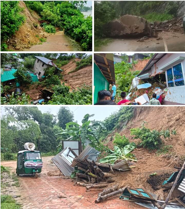
Photo: collected
Flood situation in Bandarban
Bandarban has been the worst-affected district in the Chittagong Hill Tracts, following six consecutive days of torrential rainfall and upstream runoff. Floodwaters from the Sangu, Matamuhuri, and Bakkhali rivers inundated large parts of the district after crossing danger levels.
The worst-affected upazilas include Bandarban Sadar, Ruma, Rowangchhari, Thanchi, Lama, Alikadam, and Naikhongchhari, where homes, markets, schools, cropland, and public facilities were submerged. Major road links between Bandarban town and Rangamati, Ruma, Rowangchhari, Thanchi, and Bangalhalia–Chandraghonawere cut off due to floodwaters, landslides, and the collapse of a bridge on the Bandarban–Rangamati road. Several areas also experienced prolonged electricity and mobile network outages, leaving communities isolated.
According to the district administration, floodwaters have affected 29 of the district’s 34 unions, inundating thousands of homes in more than 500 villages and leaving more than 100,000 people in distress. More than 5,000 residents from landslide-prone areas have been evacuated, while over 4,600 people have taken shelter in 54 evacuation centers.
Flood situation in Rangamati
Rangamati experienced widespread flooding, waterlogging, and numerous landslides following continuous heavy rainfall. The most severely affected upazilas include Bagaichhari, Longadu, Barkal, Bilaichhari, and Rangamati Sadar, where floodwaters inundated homes, cropland, educational institutions, roads, and public infrastructure.
More than a dozen landslides were reported across the district, blocking roads and threatening hillside settlements. The Rangamati–Khagrachhari road was severed at several locations, while landslides and flooding along the Rangamati–Sajek road stranded hundreds of tourists and disrupted transport to remote communities. Low-lying areas of Rangamati municipality and surrounding unions, including Sapchari Union, were inundated, forcing many families to seek refuge in temporary shelters. The disruption of road connectivity significantly hampered humanitarian access, while electricity outages, damaged water supply systems, and disrupted communication networks further complicated emergency response efforts.
From administrative source it is found that, in Baghaichhari 2,366 people from around 30 villages stranded by floodwaters. The local administration has opened 13 shelters to accommodate the affected residents. In Bilaichhari, four shelters are housing 183 displaced residents, while three shelters in Barkal are accommodating 152 people. Days of relentless rainfall and hill torrents have left 11,000 people marooned in the Upazila.
Although 70 metric tonnes of food grains have been allocated for flood victims in Bilaichari and Baghaichari Upazila in Rangamati District by Relief and Rehabilitation Officer (DRRO), yet it is far below what is required, making immediate assistance essential.
Flood situation in Khagrachhari
Khagrachhari also experienced severe flash flooding following continuous rainfall and overflowing hill streams. The most affected areas include Khagrachhari Sadar, Dighinala, Panchhari, Mahalchhari, Matiranga, Laxmichhari, and Manikchhari, where floodwaters inundated homes, agricultural land, markets, schools, and rural roads. Humanitarian assessments indicate that numerous remote villages became temporarily isolated as roads and bridges were submerged or damaged.
Road connectivity between Khagrachhari and Rangamati remained disrupted because of flooding and landslides, significantly delaying the movement of relief supplies and emergency services. Communities reported shortages of food, drinking water, medicines, and essential household items after remaining cut off for several days. Agricultural losses have been substantial, with paddy fields, vegetable farms, and fish ponds inundated during the peak monsoon growing season.
Overall Humanitarian Situation
Across the three hill districts, the disaster has affected dozens of upazilas and hundreds of villages, leaving thousands of families displaced or stranded. Floodwaters and landslides have damaged homes, roads, bridges, schools, health facilities, electricity infrastructure, and water supply systems. Remote Indigenous communities have been disproportionately affected due to their dependence on fragile road networks and their limited access to emergency services.
Priority humanitarian needs include emergency shelter, food assistance, safe drinking water, sanitation and hygiene (WASH), healthcare, protection services, restoration of road connectivity, and livelihood recovery. Although rainfall has eased in some locations, saturated hill slopes continue to pose a high risk of additional landslides, while many communities remain inaccessible, delaying relief and early recovery efforts.
Key humanitarian concerns include;
- Displacement of families into temporary shelters.
- Shortages of food, safe drinking water, and cooking fuel.
- Damage to sanitation facilities, increasing the risk of waterborne diseases.
- Disrupted healthcare services and limited access to essential medicines.
- Loss of crops, livestock, fisheries, and other livelihood assets.
- Interrupted education due to damaged schools and inaccessible roads.
- Continued landslide risks caused by saturated soils.
- Limited access to isolated indigenous communities in remote hill areas.
Key Actions Needed
- Scale up emergency relief, including food, safe water, shelter, healthcare, and protection.
- Restore road connectivity and ensure access to isolated communities.
- Prioritize support for vulnerable and Indigenous communities.
- Rehabilitate livelihoods through cash assistance and agricultural recovery.
- Strengthen early warning systems and community preparedness.
- Restore forests and watersheds and curb hill cutting and deforestation.
- Invest in climate-resilient infrastructure and ecosystem-based adaptation.
- Foster coordinated action for sustainable disaster risk reduction and resilience.
News links
- https://www.tbsnews.net/bangladesh/heavy-rain-paralyses-life-rangamati-1485341
- https://bdnews24.com/bangladesh/828715d4a3d8
- https://en.bd-pratidin.com/city/2026/07/11/66007
- https://www.thedailystar.net/news/environment/weather/news/bandarban-floods-worsen-over-100000-affected-4221381
- https://www.thedailystar.net/news/environment/weather/news/sajek-valley-closed-heavy-rain-raises-landslide-fears-rangamati-4218331?fbclid=IwY2xjawTAFohleHRuA2FlbQIxMABicmlkETF2OEZCUHo1b2Y3Q29jamUwc3J0YwZhcHBfaWQQMjIyMDM5MTc4ODIwMDg5MgABHnKYJuLEVC6f14JCvtfCS7dghNnMX5Th2tfN0dOPp_y3AtRXOGRJBupJIi2d_aem__vuDM7A5J6Z1k2X5XRLfJQ
- https://bangla.thedailystar.net/environment/climate-change/natural-disasters/news-3941926?fbclid=IwY2xjawTAFrVleHRuA2FlbQIxMABicmlkETF2OEZCUHo1b2Y3Q29jamUwc3J0YwZhcHBfaWQQMjIyMDM5MTc4ODIwMDg5MgABHtDETQpFU8j59xZwfz0p2btBxF_NPzOQ8VWS9t1lSOH7nNq1YAoIRfFyn2j-_aem_WPd_wxD_ZDzEkiRP8vqGJg
- https://www.thedailystar.net/news/bangladesh/news/five-including-child-killed-bandarban-landslides-4219641?fbclid=IwY2xjawTAFv5leHRuA2FlbQIxMABicmlkETE3UlJQNkxtVnc0Z08wSzBMc3J0YwZhcHBfaWQQMjIyMDM5MTc4ODIwMDg5MgABHlaIz8Tibe4lFiGPriX8_8-2CIOeqjnoLTifAhsikK9pvg4aU5GBHW6lhN_N_aem_Pms98IG8WI3USVOB2fDRqw
- খাগড়াছড়িতে জনজীবন বিপর্যস্ত, বিভিন্ন সড়ক তলিয়ে যান চলাচল বন্ধ | The Daily Star
- খাগড়াছড়িতে পাহাড়ধসের ঝুঁকি: সাড়ে ৩ হাজার পরিবার বিপদে, সড়ক যোগাযোগ বন্ধ, বন্যার আশঙ্কা | দ্য ডেইলি স্টার | দ্য ডেইলি স্টার
